

Map and Compass
People who enjoy forests and outdoor exploration should know how to use topographic maps and a compass, to navigate in unfamiliar territory. In fact, youth may enjoy their experience in a forest more if they are confident in their ability to read a map and navigate.
| Juniors | Intermediates | Seniors |
|---|---|---|
| Quiz: 10 multiple-choice questions on identifying map symbols | Quiz: 10 multiple-choice questions on identifying map symbols | Quiz: 5 multiple-choice questions on identifying map symbols |
| (no compass section) | Compass: Provide a compass bearing to reach a given point and pace out the distance between two points | Compass: Complete a compass trail by providing the bearings and distances between three points |
Using a Topographic Map
Maps can convey information about what to expect, what you might see, and how to prepare for a hike. Maps can help you identify where you are and what would be the easiest route to your destination.
Different types of maps convey different information. A road map shows highways, towns, and interesting features to visit by car. A sanitation map shows the location of the storm and wastewater sewers. A boating map shows water depth and underwater features like sandbars, sunken ships, and reefs.
For this contest, youth should know how to read a topographic map. A topographic map shows landscape features such as mountains, flat lands, waterways, major forms of vegetation, roads and different types of structures.
- Watch this video to learn how to read a topographic map
- Use the links below to learn more about topographic maps:
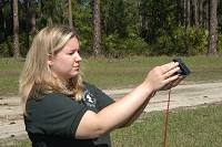
Using a Compass
A compass can tell you the direction in which you are traveling. Combined with knowing your pace, you can measure distance, communicate a location with others, return to the same spot again, and find your way home. In conjunction with a good map, you can comfortably move across a landscape you have never seen before.
Intermediates competing in the Forest Ecology Contest are expected to be able to determine the bearing of a given destination, and determine which point is indicated by a given bearing and distance.
Seniors competing in the Forest Ecology Contest are expected to be able to determine a distance by using their own pre-established pace, and determine the bearing (compass reading) of a given destination.
Use the links below to learn more about using a compass: